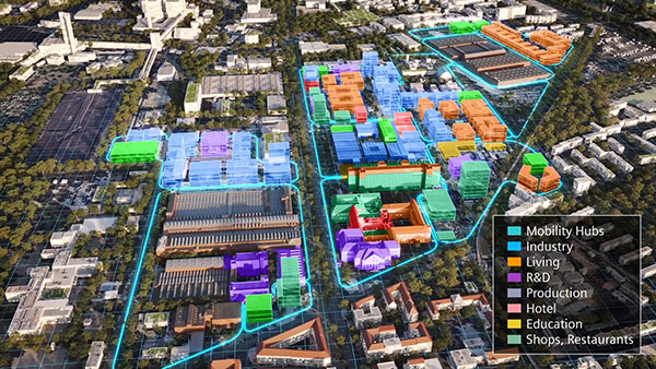
Fig. 1: Berlin, Germany, has embarked on the Siemensstadt Square project, which entails creation of a new district to be occupied by industrial, commercial, research and education groups, and cultural and social infrastructure. Leveraging the digital twin, city planners aim to create a sustainable living environment by 2035. Image courtesy of Bentley Systems.
Latest News
October 19, 2023
The time has come for smart cities to transition from expensive, limited experiments to practical projects within reach of a broad spectrum of communities. This transition’s momentum is accelerated by a number of changes in the urban environment and in the digital arena.
Rapid urbanization and population growth, increased sustainability demands, climate change and shifting popular expectations are ramping up pressure on urban planners to transform the smart city from an abstract concept to actual living communities.
This does not appear to be just a passing fad. The public and private sectors have shown a willingness to fund smart city projects. For example, the U.S. Infrastructure Investment and Jobs Act, passed into law in 2021, provides more than $1.2 trillion for smart city projects. Furthermore, according to Smart Cities World, the market for these metropolises may well reach more than $2 trillion by 2025.
Adding to this momentum, the emergence and cultivation of digital twin technology promises to provide the final boost required to propel smart cities into the mainstream. The injection of these platforms will accomplish this by giving urban planners better tools to take on such projects.
“By thoughtfully implementing digital twin technology, planners empower themselves to complement intuition and experience with direct insight on the city itself,” says Zak Kostura, digital team leader and associate principal at Arup. “That insight comes from real-time data streaming from the existing city infrastructure, as well as from organized historic data that captures the decisions and thought processes of planners who worked on the city in the past. When properly implemented, a digital twin aids planners by making problems easier to understand.”
The Right Tools for the Task at Hand

Fig. 2: Digital twin technology enables the development of sustainable structures that can withstand challenging weather conditions. Image courtesy of Siemens Digital Industries Software.
But what makes digital twin technology such a good match for smart city development? To answer this question, consider the complexity of the smart city itself, the interrelationships and interactions of the elements in play and the multilayered tasks involved in such undertakings.
With these issues in mind, it becomes apparent that one of digital twin technology’s most important features is its ability to provide urban planners and other stakeholders with a holistic view of development efforts. This visibility extends from microscale actions to macro systems and processes. Empowered with this perception, all players are able to see whether local changes will succeed or fail and visualize how the changes will impact the whole urban organism (Fig. 1).
“There are so many variables involved that if you don’t use a comprehensive digital twin that enables you to really understand all of these different elements of a city that need to interact, you won’t be successful,” says Dale Tutt, vice president of industry strategy at Siemens Digital Industries Software. “The amount of data and interactions that are involved cannot be understood with traditional, manual technology. You must have a comprehensive digital solution because these models are going to be complex. Between the model of a building, the model of a traffic control system and the model of how people interact and move about—understanding all of this and synchronizing it is going to be a significant challenge” (Fig. 2).
Leveraging the technology’s advanced modeling and simulation capabilities, digital twin helps to ensure the interconnection and configuration of the different elements that make up the whole.
“The primary function of the digital twin of a city is to offer an immersive 3D visualization experience that provides a clear understanding of how specific areas fit together,” says Vince Gattola, architecture, engineering and construction, and civil infrastructure industry process consultant senior manager at Dassault Systèmes. “By adding collected data, the digital twin can enable descriptive analysis, predictive modeling and scenario simulation capabilities that help urban planners to make data-driven decisions.”
With the ability to now predict and simulate the behavior of complex systems and processes in city organizations, urban planners can foresee and plan for potential issues or propose new improvements in the built environment.
“One of the obvious advantages of being able to visualize and simulate operations with digital twins is the contextual aspect,” says Dominik Tarolli, director of smart cities at Esri. “For example, organizations can optimize maintenance resources to better allocate them to areas that require immediate attention.”
The Key Is in Data Management
The digital twin’s ability to handle this complexity, however, calls for leveraging of the platform’s data management strengths.
“Cities are a system of systems, and digital twins allow urban planners to combine many data sources to create a systemic view of a single geography or entire community,” says Tyler Svitak, executive director of Colorado Smart Cities Alliance. “These virtual replicas are flexible in time and scale, which makes them both planning and operations tools. If you have real-time data about a system, for example, the city can control its infrastructure in real time, but they can also simulate future events to plan for different scenarios.”
Extracting these benefits requires skill and diligence on the part of the developer. The design and construction of an accurate virtual replica that balances competing interests takes time and thoughtful effort.
“Cities produce vast amounts of data, and the purpose of a digital twin is to enable its human users to navigate through that data to make meaningful decisions,” says Kostura. “To do this, agencies must define the most important use cases for the digital twin. Then, the digital twin is built or scaled around those specific needs in a strategic and coherent way. A well-designed digital twin can be built out in stages, providing incremental value along the way.”
An example of the volume of data that can come into play can be seen in the efforts of the city of Chattanooga, TN, to optimize traffic flow. In this case, the planners used data from 500 different sources. These included data from the 911 system, traffic cameras and weather stations.
This balancing act requires maximum knowledge of how a city functions on a day-to-day basis and an understanding of how and where all city systems and assets interact.
“By being able to layer datasets on top of one another, officials can make connections and really pinpoint how a city’s systems are functioning,” says Tarolli.
Implementing a digital twin for urban planning requires a commitment to data integration and interoperability, which can be a challenge.
“Digital twin’s potential for impact relies heavily upon the quality of the data fed into the system,” says Lena Geraghty, director of sustainability and innovation at the National League of Cities. “Before jumping directly into adopting digital twin technology, local leaders need to carefully consider the availability and quality of these data inputs.”
A Blueprint for all Stakeholders
Another capability that makes digital twin an effective toolset for the development of smart cities is its ability to provide a single source of truth for an eclectic variety of stakeholders. By offering a good collaborative environment for multiple disciplines and various levels of technical expertise, digital twin provides a make-or-break feature for any smart city development effort’s success.
Typically, urban environments are complex and very diverse, with use cases involving many disciplines, teams, tools and data formats. These use cases require clear objectives and commitment from city leadership to remove inertia and demand collaboration.
“Digital twins enable a system-of-systems approach that empowers open collaboration in an urban ecosystem,” says Richard Vestner, vice president, cities, at Bentley Systems. “Digital twins are essential to drive and scale up partnerships and ecosystem collaboration. These capabilities advance transparency, communication and decision-making in urban areas. They enable knowledge blending and understanding of technical experts with elected officials and other people who may not have a lot of prior technology expertise.”
The bottom line is that any successful effort to develop the interconnected fabric of a smart city must be a holistic enterprise, with each area of development dependent on changes in another. This means bringing together the interests of everything from mobility infrastructures, sustainable power grids for renewables, grid-scale battery storage and connected digital services.
“Transforming urban areas into smart cities requires multiple stakeholders to work together, from national governments, local authorities and community associations to the private sector, construction firms and financial services,” says Dassault’s Gattola. “These complex interconnected dynamics in city planning are fully addressed by virtual twins, which facilitate collaborative management, boost efficiency and improve the quality of city life.”
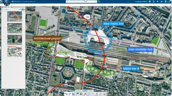
Fig. 4: Urban planners of Rennes, France, created a digital twin of the city, based on geometric and topographical elements, as well as demographic, mobility and health data. Image courtesy of Dassault Systémes.
When implemented properly, digital twin technology helps city decision makers, as well as citizens, more easily understand and agree on a common representation of their city. The technology helps city teams visualize, identify and simulate impacts of public policies, leveraging data from various departments, governmental agencies and private third parties (Fig. 3).
Digital Twin Designs the Soul of the City
The pairing of digital twin technology and smart city development has already begun to make the transition from theory to practical application, with the value of the virtual replicas already a matter of record. In fact, market watchers predict twin technology will deliver significant savings to cities embracing the latest generation of digital design and planning tools.
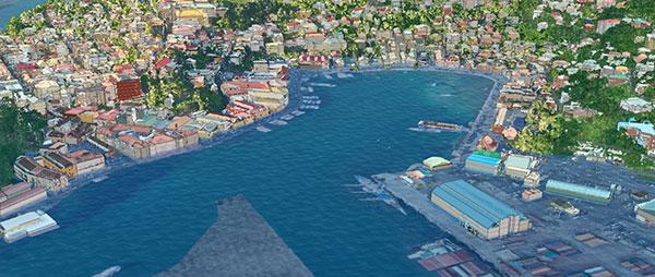
Fig. 5: Digital twins can help cities plan for extreme weather events and results of climate change, such as flooding and rising sea levels. Image courtesy of Esri.
For example, a 2021 ABI Research report on urban planning and digital twins estimated that digital twin technology could save cities $280 billion by 2030 by making urban planning more efficient. Twin technology has already been used by cities ranging from Orlando, New York, Los Angeles and Phoenix to Berlin, Germany, and Uppsala, Sweden.
Examination of a few key areas currently receiving a lot of attention by urban planners paints a clear picture of just how much digital twin technology can contribute to smart city development processes.
One such area is the development of smart infrastructure and city services. Here, the considerations addressed in smart city design goes beyond traditional parameters and reflects the complexity of today’s urban service systems.
“With advancements in technology, we’re seeing better designed buildings, structures that can stand up to natural disasters,” says Tutt. “When considering the interactions of these buildings, you have to take into account how the [computational fluid dynamics (CFD)] analysis changes when you have a lot of buildings across a large area, as opposed to just individual buildings. Digital twin technology allows you to understand this no matter the size of the city or cities.”
Even more complex are the design considerations given to subsurface urban networks. Subway, water, sewage, communication and power systems all compete for space, the most efficient connections and the most effective maintenance accessibility.
“Infrastructure digital twins include information about these networks, and by toggling transparency, it’s possible to view these assets in a 3D presentation of a city and plan all these networks sharing one source of truth between different departments,” says Vestner. “Due to engineering accuracy, clash detection is possible, which reduces errors and rework.”
An example of this can be seen in a recent project in Berlin, Germany, where a new district of 72 hectares is being developed, with the initial stages being performed virtually. By doing this, the Siemensstadt Square project data is shared across all involved disciplines and across the entire lifecycle. All stakeholders can get information and visualize design choices, and then select the best option.
How to Make Smarter Roads
Another area of the infrastructure that is benefiting from the use of digital twin technology is the development and upgrading of city transportation systems.
“Digital twins provide city planners, mobility leaders and their contractors with a common referential with visualization and modeling capabilities to design and plan infrastructure projects that simulate traffic behavior,” says Gattola. “These platforms take into account factors like traffic signals, vehicle speeds and congestion. Planners can also simulate various scenarios—such as accidents, road closures or special events—to understand their impact on traffic flow” (Fig. 4).
Digital twins also use machine learning algorithms, which can use historical data to predict future traffic patterns and identify where bottlenecks are likely to occur. This way, planners can manage these areas proactively and appropriately.
Dealing with Extreme Weather
Infrastructure has always been built with an eye toward the weather. Floods that were previously considered once-a-century events now occur once a decade. Hurricanes seem to be increasing in frequency and severity. Further, the extreme nature of these events increasingly appears to lead to cascading effects. This is where digital twins’ ability to model and simulate scenarios becomes increasingly critical.
“Digital twins are powerful enough to be able to integrate enormous amounts of data so that hundreds or even thousands of possible scenarios can be visualized and considered,” says Tarolli. “The likelihood of these scenarios can become part of important cost-benefit analysis. If flood waters come this far inward, how do we ensure that power networks continue to function? (Fig. 5). If an earthquake of this magnitude happens, where are the ruptured gas lines—and attendant fires—likely to be?”
The common denominator is that a digital twin, with its power of data integration, artificial intelligence capabilities and visualization can help cities face an inherently unknown future with as much known information as possible.
More Bentley Systems Coverage
More Dassault Systemes Coverage

More Siemens Digital Industries Software Coverage
Subscribe to our FREE magazine, FREE email newsletters or both!
Latest News
